A Happy Place
I decided to sign up
for 24 Hours in the Old Pueblo as a solo racer in 2017. I got the party
experience the year before as part of a 7 man team. I got to ride two laps, on
my single speed, both of them taking place with my lights on. During the
weekend I actually spent a lot of time sitting around, relaxing, and watching
other racers. It was fun, but I wanted a different experience for myself this
year. A challenge that would hurt. An experience where I might find out new
things about myself and what I am capable of.
My goal for Old
Pueblo is a minimum of 6 laps, or about 102 miles, with a hope for more. In
order to reach this feat I really needed to ramp up my distance training and
get out and ride. This isn't that hard for a roadie to accomplish, but I sold
my road bike due to the fact that road riding scares the hell out of me.
Luckily, though, the area south of Estrella Mountain Ranch in Goodyear is
covered by a seemingly endless system of little traveled dirt roads that
provide countless miles of riding that I could use for training.
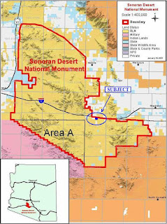
South of Goodyear is
the Sonoran Desert National Monument. The monument is a large area of land that
is protected from future development and has grazing restrictions, making it a
beautiful escape into nature. Within the monument are three wilderness areas,
the North Maricopa Mountains wilderness area, the South Maricopa Mountains
wilderness area, and the Tabletop Mountains wilderness area. I have been to
both the Maricopa Mountains wilderness areas but have not yet reached the
Tabletop Mountains wilderness area, which is south of interstate 8. Maggie's
Cove is a happy place nestled in the middle of the North Maricopa Mountains
wilderness area.
Riding to Maggie's
Cove is a 43 mile out and back from my house. While I am not a huge fan of out
and back rides, I am a fan of riding to a destination, and making that my goal.
Usually destination rides result in an out and back, unless there is ample time
to find another route, but that would consist of riding a circumference of the
wilderness area and the mountain range, which is not feasible for a routine
training ride. Starting south from my house I make it a goal when riding to
Maggie's Cove to keep my tires on dirt as long as possible. There is a small
section of pavement, but not enough to take away from the adventure that this
trip is.
Heading south from
my house I can ride on dirt almost immediately. To start the ride and head out
of town I get on the Corgett Wash trail, cross the road and ride through the
golf course on an unpaved service road, and then follow the power lines past FINS
to Rainbow Valley road. On Rainbow Valley the community of Estrella begins to
be left behind as farm fields, ranches, and dairies begin to pop up on the
terrain. Shortly after hitting the broken pavement of Rainbow Valley road there
is a cattle guard with a no cycling sign, rolling over it is fine on a mountain
bike, however take caution with skinny tires and make sure you do not get
caught in the middle, sending you over the bars. Continue south for about a
mile on pavement until you cross the Waterman wash, where you can turn right on
the unpaved Queen Creek road and start heading west on the dirt.
Queen Creek road
from Rainbow Valley road to 207th avenue is a great stretch of dirt to ride on
in either direction. Going west there is a slight uphill, nothing too
noticeable but you will likely be traveling faster on the way back. This three
mile stretch of road is continually maintained and graded for the farm vehicle
traffic that uses the road. Once Queen Creek and Tuthill roads intersect you
will ride by a giant dairy. It smells a bit, but make sure to say hi to the
cows as they watch you ride by. They always seem interested in seeing a
cyclist, a break from their usual scenery I guess. About a half mile past
Tuthill turn left and head south on 207th avenue, a maintained dirt road with a
slightly bigger incline than Queen Creek that will get your heart pumping as
you pedal a bit harder.
This part of Rainbow
Valley seems to be scattered with plots of land owned by people who want to be
away from society a bit. Houses seem to be about a mile apart from one another,
some are broken, dilapidated, no longer have anybody living in them, and have
been left for nature to take back over. A small few are elegantly built houses
with large fenced in yards for chickens, horses, dogs, and whatever other
animals people chose to have. But mostly, in this area, are single wide
trailers with a lot full of cars that will probably never travel again and
trash waiting in piles to be burnt. Riding by I wonder what people are trying
to escape from living out here. Do they have a reason, and what do they do for
recreation? Do they have pluming, running water, and electricity or are they
living a life off the grid? I continue to pedal though, because I believe that
people living so far out on a dirt road are the type that like to be left alone
and not those who would like to engage in a conversation with a curious
cyclist.
The further south
you pedal on 207th avenue the less maintained it becomes, but it is nothing
that cannot be handled by a bike or even a regular passenger car. There are
some sandy and bumpy areas and for me it is a relief to reach Riggs road at the
end of 207th to start heading further west. Riggs road is a wide, maintained,
dirt road. There is a bit of an up slope heading west for a few miles. You will
be on Riggs road for about 3 miles before reaching the road that enters the
wilderness boundary, just before the intersection with the Gas Line road, right
after the Rainbow wash. You can see the large sign for the Sonoran Desert
National Monument once you cross the Rainbow wash which serves as a landmark
when turning off Riggs onto an unmarked dirt road to reach the sign. The
Sonoran Desert National Monument, as well as the North Maricopa Mountains
Wilderness Area lies south of the Gas Line Road where you begin to go up into
the mountains and the scenery gets prettier with each pedal stroke.
To reach Maggie's
Cove campground and trailhead continue south on the dirt road marked with
Wilderness markers, road 801A. On the map, it is listed as Woods road. Be
prepared for this and seek out some satellite info on Google. It isn't that
hard to get lost, but one of my friends did. There are a few unmarked
crisscrossing dirt roads and there is no cell phone reception when you are
between the mountains. The road up into the mountains is a well maintained
double track gravel road. As elevation raises, the soil goes from a fine dust
to more of a kitty litter gravel. Going through some small washes before
reaching the saddle can put a little slip on the tires, but there is nothing
impossible to pedal through. Nearing the saddle, you cross over another cattle
guard from a time in history when grazing was allowed in this area - I did not
notice any barbed wire to the sides or see any cows - so I do not believe there
is grazing any longer in this protected area - and you can tell by the dense
vegetation painting the beautiful scene before you. After the cattle guard
there is a slight left hand turn, staying on the Wilderness Road 801A the
incline begins to flatten out a bit. Look behind you here and you will see how
far up you have gone, with views of the Estrella Mountains to the East, the
White Tank mountains to the north, and the Buckeye Hills to the west. On a
clear day you can see landmarks in the city, including University of Phoenix
Stadium.
Continuing on past
the cattle guard you will pedal through some loose soil and climb just a little
more until you get to an intersection. Remaining on 801A or Woods road will
take you out to state route 85. This is good to know if you are tired, out of water,
or need an exit strategy. Pedal about three miles and you will meet the highway
right by the state prison. Taking a left will drop you down into Maggie's Cove,
the final destination of this trip. The downhill is not steep, but it does ease
the effort you need to put into pedaling as you descend into the cove.
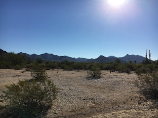
Reaching Maggie's
Cove is a surprise. As you drop down, you can no longer see the city and you
become surrounded by the hills of the North Maricopa Mountains on all sides.
The cove is complete with about eight campsites with designated parking areas
and iron fire pits. At the south end of the campsite there is the Maggie's Cove
trailhead. The trail looks like something fantastic to ride, but riding bikes
on Wilderness trails is not allowed. The
upcoming weekend I will be taking the Subaru back to this happy place with the
family to explore and hike down the Maggie's Cove trail. The trailhead is
complete with a map, information, a sign in log, and pamphlets that you can
take with. There is also a bathroom, but no running water, so don't plan on any
refills out there! In the future, I have plans to take my boy camping at this
location. We might do a guy's camping night out there as well.
After taking a rest,
soaking up some nature, and having a snack it is time to turn back home. From
Estrella Mountain Ranch this is a 20-25 mile ride to the cove depending on your
starting location. The way back is primarily downhill but the first few miles
you will be climbing back up the road you just came down. Once getting to the
saddle you will begin to see the sites you saw before when you looked back. The
White Tanks, the Estrellas, and maybe some landmarks in the city on a clear
day. The roads heading back north are all downhill until the first cattle guard
you crossed on the pavement of Rainbow Valley road. This makes for an enjoyable
ride if the wind is not in your face. If it is, as I learned last weekend, it
will still be quite an effort.
In all, Maggie's
Cove is a great little spot in the Wilderness that is not too hard to get to
from the city. For a mostly pavement option by car enter Wood's road from State
Route 85 near the state prison. The road is probably drive-able with a regular
passenger car, but having something with all-wheel drive and a little bit of
clearance will have you feeling more comfortable. From Estrella Mountain Ranch
I suggest taking the dirt roads and soaking in the scenery of the area
described in this post.


No comments:
Post a Comment